
Battlefield Graphics
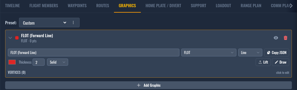
The Graphics tab is for battlefield graphics — the lines, areas, and corridors you draw on the map to mark up the battlefield: FLOTs, FAORs, ROZs, fire-support lines, air corridors, phase lines, and so on. They render on the kneeboard map pages and, for the F-16C and F/A-18C, can be sent straight into the jet's in-game DTC.
Battlefield graphics aren't the only thing that rides the in-game DTC, though. The June 2026 update also fills the jet's pages from data you've already entered on other tabs — your threats, CAP tracks, and Range Plan destinations. Those are covered in Additional DTC graphics at the bottom of this page.
Shape vs. Kind
Every graphic has two independent settings, and it's worth keeping them straight:
- Shape is the geometry — what it looks like on the map:
- Line — an open polyline (start to end, no closure).
- Area — a closed polygon (the last vertex joins back to the first).
- Corridor — a polyline rendered as a band of a fixed Width in nautical miles.
- Kind is what it means doctrinally (FLOT, FAOR, ROZ, FSCL, …). Kind drives the default color and line style, and — importantly — it decides where the graphic goes when you export an in-game DTC (see below).
Picking a Kind sets a sensible default Shape, but you can override the Shape afterward without changing the Kind.
Drawing a graphic
- Click Add Graphic. A new row appears and drops straight into draw mode.
- Click the map to drop vertices; right-click a point for options. Use the undo arrow to remove the last vertex.
- Click Finish when the shape is complete.
- Expand the row to set its Name, Short, Kind, Shape, color, thickness, line style, and (for corridors and areas) width and fill.
Short is an optional label of up to four characters, the same idea as a waypoint's SHORT. It exists for cartridges that carry a tiny per-line tag — the AH-64D's phase lines are the one that does today. Leave it empty and nothing changes.
The eye icon toggles a graphic's map visibility without deleting it. A hidden graphic is also left out of DTC exports — see the note below.
Lift copies an imported mission drawing's exact shape into a graphic. Expand a graphic, click Lift, then click any drawing from a loaded theater overlay — the graphic takes on that drawing's shape, style, and color with no vertex-by-vertex tracing. The map highlights the drawings while you pick, even if the Drawings layer is hidden.
Sending graphics to the in-game DTC
The June 2026 DCS update added map geometry to the in-game DTC. When you export a DTC cartridge (or Export to DCS) for a Viper or a Hornet, DKS routes your battlefield graphics into the jet's pages. Which page a graphic lands on is decided by its Kind (and, for the Hornet, the Corridor shape) — this is the part that isn't obvious from the dropdown, so here is the full mapping:
| Graphic Kind / Shape | F/A-18C Hornet (SA page) | F-16C Viper (GEO LINES) |
|---|---|---|
| FLOT | FLOT line | GEO line |
| FAOR | FAOR area (closed) | GEO line |
| Air Corridor | Corridor | GEO line (centerline) |
| MRR (Minimum Risk Route) | Corridor | GEO line (centerline) |
| Custom kind drawn as a Corridor shape | Corridor | GEO line (centerline) |
| Any other Kind (Airspace Boundary, ROZ, HIDACZ, MOA, FSCL, CFL, FFA, RFL, NFA, RFA, ACA, Phase Line, Axis of Advance, Battle Position, Engagement Area, plain Custom) | — not sent to the jet (kneeboard map only) | GEO line |
The two airframes treat graphics very differently:
- F/A-18C Hornet — the SA page is opt-in by Kind. Only graphics tagged FLOT, FAOR, Air Corridor, or MRR (or a Custom graphic drawn as a Corridor) are sent to the jet. Everything else stays on your kneeboard map and is ignored by the Hornet's DTC. So if you want a line on the Hornet's SA page, tag it FLOT or FAOR — a Phase Line or Airspace Boundary won't get there no matter how it's drawn.
- F-16C Viper — the Viper has no FAOR/corridor concept, so every visible graphic — regardless of Kind — exports as a GEO line. Lines and corridor centerlines go as-is; areas export as their closed boundary.
Limits per section
DCS caps how much geometry each page holds. DKS exports in the order the graphics are listed and skips the overflow (it records a warning when it has to):
| Section | Max lines | Max points per line |
|---|---|---|
| F-16C GEO LINES | 4 | 25 total points across all lines |
| Hornet FLOT | 3 | 7 |
| Hornet FAOR | 3 | 7 (the closing point counts toward the 7) |
| Hornet Corridors | 7 | 14 |
When there's more than fits
A section can run out of room two ways — too many lines, or too many points in a single line — and DKS handles them differently:
- Too many graphics for a section — they're taken in the order they appear in the Graphics tab list (the order you added them), and the ones that fit are exported; anything past the limit is left out. So add the graphics you most want in the jet first, and keep the count within the limits above.
- Too many points in one graphic — DKS simplifies the shape to fit, rather than cutting off the end: it keeps the vertices that define the shape (the corners and bends) and drops the least-significant points in between, so the line still matches what you drew.
On the Viper, the 25-point GEO-line budget is split across however many lines you export — each line gets an even share (at least 2 points), with any remainder going to the earliest lines. Fewer lines means more points per line.
AH-64D Apache
The Apache takes graphics into its own TSD stores, and — unlike the Viper and Hornet — it sorts them by Kind:
| Graphic Kind / Shape | AH-64D TSD store |
|---|---|
| Boundary, FEBA, FLET, FLOT, FSCL, LD, Phase Line | Lines (each drawn in that measure's own TSD style) |
| Any other line or corridor Kind | Lines, drawn as a PL (the jet's generic labelled line) |
| No Fire Zone, No Fire Area | Zones → NFZ |
| Priority Fire Zone, Kill Box, Free Fire Area | Zones → PFZ |
| Any other area Kind | Areas |
A PL is the only line the Apache labels, and the label is just three
characters. DKS uploads the graphic's Short as that tag. If Short is empty it
falls back to the first three characters of the Name, which is rarely what you
want — a graphic called "PL TEXAS" chops to "PL", so every phase line ends up
tagged the same. Give each one a Short (TX, MO) and they stay tellable apart
in the cockpit.
A graphic that's hidden on the map (eye toggled off) is left out of the DTC export entirely — hiding it is treated as a deliberate "don't send this" choice. Graphics with too few points to form a shape (a line or corridor with fewer than 2 points, or an area with fewer than 3) are also skipped.
Additional DTC graphics
Battlefield graphics from this tab are only part of what the in-game DTC carries. The June 2026 update also fills the jet's pages from data you've already entered elsewhere — no extra drawing required. Here's where each one comes from and where it lands:
| Source — where you set it | F-16C Viper | F/A-18C Hornet |
|---|---|---|
| Threats (OpFor tab) | THREAT points — position, type, ring, label | MEZ rings (ringed threats only) |
| CAP / CAP-L waypoint pairs (Flight Plan) | — | CAP points (racetrack) |
| Tanker / AWACS orbits & map tracks pinned to a waypoint | — | CAP points (racetrack) |
| Range Plan waypoints | DEST points | — |
Threats
Every threat on the OpFor tab that's visible and placed on the map is sent to the jet:
- Viper — each becomes a THREAT point carrying the threat's position, type, threat-ring radius, and a label (steerpoints 56–70, up to 15 threats).
- Hornet — the SA MEZ page is rings-only, so only threats that have a threat ring export as MEZ rings (up to 40). A threat with no ring is left off the MEZ page; the ring radius is read in nautical miles.
Threats hidden on the OpFor tab (eye toggled off) aren't sent to either jet.
CAP tracks
The Hornet SA page's CAP points are built from three sources, combined in this order up to 9 total:
- CAP / CAP-L waypoint pairs in your flight plan — DKS detects the racetrack from the pair the same way it draws it on the kneeboard map.
- Standalone map tracks your flight has pinned a waypoint to.
- Tanker / AWACS orbits (support assets) your flight has pinned a waypoint to.
Each exports as a racetrack — anchor, course, length, and turn direction — matching the orbit DKS renders on its own maps. A pinned orbit that's only half-placed (2 of its 3 control points) is skipped with a warning. The Viper has no CAP page, so CAP tracks aren't sent to it.
Range Plan destinations
Viper only. The Viper's DEST page (steerpoints 81–99, up to 19) is filled from your Range Plan waypoints, in list order, skipping any row without a position. Each point gets a 3-character HSD label derived from its description (e.g. Departure → DEP), with the full text kept as the point's note.
Home Plate / Divert airfields are not exported to DEST.
SA sensor & declutter settings
Hornet only. The SA page's sensor and declutter settings ride along with the
cartridge too. Set them in your F/A-18C DTC profile or your squadron's F/A-18C DTC
config, or import them from a .dtc you saved in the jet — see
Squadron Settings.
After the cartridge loads on the Hornet, the first CAP point, corridor, FAOR line, and FLOT line you exported each become that page's pre-selected item — unless your F/A-18C DTC config names a specific default.
Sending graphics to the jet is part of the broader in-game DTC cartridge — see Exporting Kneeboards → DTC Export for how to download and load the cartridge, and which other data (waypoints, comms, radios) rides along.